This March and April, University of Illinois Atmospheric Sciences faculty will lead a multi-institutional team of researchers to study tornadoes and other severe weather in the southeast US. The project is called PERiLS, which stands for Propagation Evolution and Rotation in Linear Storms, and will be based in Memphis, Tennessee, near an understudied severe weather hotspot that can produce deadly tornadoes, often in the winter and at night, and are extremely difficult to predict.
The primary objective of PERiLS is to understand how “quasi-linear convective systems” (QLCSs, sometimes called “squall lines”) produce tornadoes. This will lead to a better understanding of how these challenging events can be more accurately predicted. QLCSs are common to the southeast U.S. as well as the Midwest and are known to behave differently than the “supercell storms” that often form tornadoes more commonly on the Great Plains and during the day.
PERiLS-NSF lead scientist, and Atmospheric Sciences adjunct associate professor Karen Kosiba, says “As recent tragic events have shown us, Southeastern nighttime tornadoes can be particularly violent and deadly. PERiLS hopes to learn more about the complex ways these tornadoes form. If we can learn how, why, when, and where they will form, then we can make better predictions, more precise and longer-lead time warnings, and save lives.”
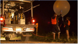
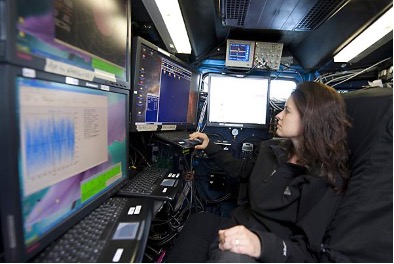
Dr. Kosiba, along with faculty and students from the University of Illinois, North Carolina State University, other universities, and research laboratories around the country, PERiLS will field several mobile radars, including Doppler On Wheels (DOWs) and the C-Band on Wheels (COW) from the new University of Illinois Flexible Array of Radars and Mesonets (FARM), an array of Mobile Mesonet, truck-borne mobile weather stations, a Wind Profiler, arrays of quickly-deployable, targetable, weather stations, and a fleet of vehicles deploying hundreds of weather balloons ahead of, and into, potentially tornadic storms.
According to Dr. Kosiba, “During PERiLS, when severe weather including tornadoes are forecast, the teams will head out from Memphis to pre-selected deployment sites in the southeast, including Louisiana, Arkansas, Alabama, Tennessee, Mississippi, Kentucky, and Illinois. The DOWs, COW and other radars will triangulate on the storms, in a configuration we call multiple-Doppler, while a diverse array of instruments are deployed ahead of and in the path of these storms.”
The team hopes to assemble the collected observations, model simulations, and current understanding of convective storms into knowledge and tools that will help forecasters and local residents be better prepared for these hazardous storms.
PERiLS is supported by the National Science Foundation (NSF) and the National Oceanic and Atmospheric Administration (NOAA).